Description
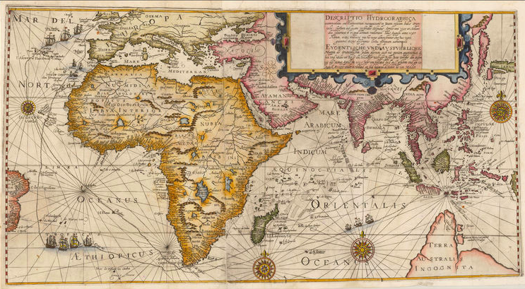
Antique world map by de Bry titled ‘DESCRIPTIO HYDROGRAPHICA accommodate ad Battavorum navagatione in Javam infulam Indie Orien: talis. Laetam ad quam poftridie Calendis Aprilis ann 1595 ex Hollan dia folverunt et ex qua domum redierunt Idus Augufti anno 1597 Horum extus, reditusq’ via his notis demonftratur De hac navi gatrone extat defcriptio loctu perquam admiranda’.
Late 16th century antique world map by de Bry showing the outbound and return routes of Cornelis De Houtman’s pioneering voyage to the East Indies between April 1595 and August 1597 that was published in Part III of the 1599 German edition and the 1601 Latin edition of Theodore De Bry’s Petit Voyages. The map covers the whole route from Amsterdam and includes the southern part of England, the coastline of Europe from the Low Countries to Spain, the whole of Southeast Asia including the Indonesian archipelago as far north as the north coast of New Guinea, with Terra Australis Incognita containing the usual array of islands and places (Beach, Maleteur and Loach) derived from Marco Polo’s travels. The map also shows a small portion of the coast of Brazil, the most westerly point of the journey to the east where the sailing ships picked up the strong westerly winds for the journey across the Atlantic and Indian Oceans.
The Dutch Pioneering Voyage to the East Indies
The last decade of the 16th century heralded the emergence of the Dutch as the colonial power that was to supersede Portugal as the premier trading nation in Asia and establish a tyrannical hold on the East Indian Islands and the trade therefrom for the next 350 years. Dutch navigators, already familiar with the waters of the North Sea and the Baltic, probed vainly for a northern route to the Far East that would circumvent the Spanish and Portuguese fleets patrolling their trade routes, but the passage could not be found.
In desperation, the Dutch decided to fight their way to the Spice Islands and Southeast Asia by way of the coast of Africa and the Cape of Good Hope. This period of Dutch dominance, begun with the exploratory voyages of Cornelius de Houtman to Bantam, a northwestern port in Java.
In 1592 Cornelis de Houtman was sent by Amsterdam merchants to Lisbon for four years to discover as much information on the Spice Islands as he could. When he returned to the Netherlands he brought with him precious information about the seas and lands of the East, and details about the strengths and weaknesses of the Portuguese. De Houtman determined that Bantam (Banten) provided the best opportunity to buy spices.
In 1594 the Dutch company ‘compagnie van Verre’ (meaning: the long-distance company) was founded, and on April 2, 1595 four ships with on board 249 man left Amsterdam in search for the Spice Islands. The voyage was beset with trouble from the start, and scurvy broke out after only a few weeks, due to insufficient provisions. At Madagascar where they stopped briefly, seventy people had to be buried. On June 27, 1596 the ships finally arrived at Banten, Java. The information stolen from the Portuguese learned them to not pass through the Malacca Strait, which was controlled by the Portuguese, but through Sunda Strait between Java and Sumatra.
At Java De Houtman was introduced to the Sultan of Banten, who promptly entered into an optimistic treaty with the Dutch, writing “We are well content to have a permanent league of alliance and friendship with His Highness the Prince Maurice of Nassau, of the Netherlands and with you, gentlemen.” The local Portuguese traders became very conspicuous when De Houtman did not buy any black pepper, and wanted to wait on the next harvest. De Houtman was undiplomatic and insulting to the sultan, and was turned away for “rude behaviour”, without being able to buy spices at all.
The ships then sailed east to Madura, and were attacked by pirates along the way. In Madura, they were received peacefully, but De Houtman ordered his men to brutally attack the civilian population in revenge for the unrelated earlier piracy.
The ships then sailed for Bali, where they met with the island’s king in February 1597 and managed to obtain a few pots of pepper. At Bawean, an island north of East Java, one of the ships was purposely set on fire, and the crew divided over the other three ships. When the sailors had enough of the exhausting voyage, it was decided not to go to the Moluccas as planned, but return to Holland.
On their route back to Holland Portuguese ships prevented them from taking on water and supplies at St. Helena. Out of the 249 crew members that left two years earlier only 87 returned, too weak to moor their ships themselves. Though the trip was a humanitarian disaster and financially probably just broke even, it was a symbolic victory. Within five years, sixty-five more Dutch ships had sailed east to trade. Soon, the Dutch would fully take over the spice trade in and around the Indian Ocean.
Artist: T. de Bry
Year: 1599
Purchase Code: M2414
SOLD