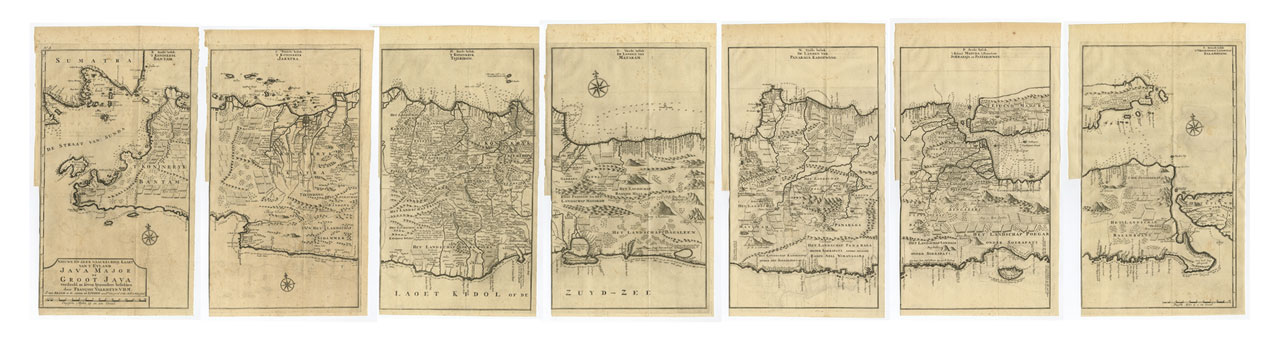
Antique Map Java in 7 Sheets by Valentijn (c.1724)
Antique Map Java by Valentijn titled ‘NIEUWE EN ZEER NAAUKEURIGE KAART VAN T EYLAND JAVA MAJOR OF GROOT JAVA verdeeld in feven byzondere beftekken door FRANCOIS VALENTYN. V.D.M / J. VAN BRAAM et G. ONDER DE LINDEN.excudnt Cum privil. Ordin. Holl: et West-friesl’.
The extremely rare and much sought-after map of Java on seven sheets by Francois Valentyn that was bound into his eight-volume history of the East Indies entitled Oud en Nieuw Oost-Indien that was published in Amsterdam by Gerard Onder de Linden and the bookseller Joannes van Bram between 1724 and 1726. The work contained numerous charts of the major islands including this large map of Java which consists of seven separate printed sheets that when joined, form the longest map of Java, at 1.75m, ever printed. The map has soundings around the whole coastline of Java and a lot of information on land-use, topography and settlements in early 18th century Java.
François Valentijn: A Brilliant Braggart
Francois Valentijn (1666–1727) was a minister, naturalist and writer. He is best known for his Oud en Nieuw Oost-Indien(“Old and New East-India”), a book about the history of the Dutch East India Company and the countries of the Far East.
Valentijn was born in 1666 in Dordrecht, Holland, but spent significant time in the tropics, notably in Ambon, in the Maluku Archipelago,. In total, Valentijn lived in the East Indies 16 years. Valentijn was first employed by the Dutch V.O.C. or East India Company (Vereenigde Oost-Indische Compagnie) at the age of 19, where he served as Minister to the East Indies. He returned to Holland for about ten years, before returning to the Indies in 1705 where he was to serve as Army Chaplain on an expedition in eastern Java. He again returned to Dordrecht where he wrote his Oud en Nieuw Oost-Indien (1724–26), a massive work of five parts published in eight volumes and containing over one thousand illustrations and including some of the most accurate maps of the Indies of the time. He died in The Hague, Netherlands, in 1727.
Valentijn probably had access to the V.O.C.’s archive of maps and geographic secrets which they had always guarded jealously. Johannes Van Keulen II became Hydrographer to the V.O.C. in the same year Valentijn’s book was published. It was in Van Keulens time that many of the VOC charts were published, one signal of the decline of Dutch dominance in Spice Trade. Valentijn was fortunate to have seen his work published, as the VOC (Dutch East India Company) strictly enforced a policy prohibiting former employees from publishing anything about the region or their colonial administration. And while, as Suárez notes, by the mid-18th Century the Dutch no longer feared sharing geographic secrets, the execution of this policy was still erratic and based on personal motives.
While Valentijn’s maps and diagrams were prized possessions, his scholarship, judging by contemporary standards, was not of the highest integrity. While current standards of referencing and plagiarism were not in effect during the 18th Century, Valentijn’s borrowed liberally from other scientists’ and writers. E.M Beekman referred to Valentijn as an “exasperating Dutch braggart,” but nevertheless cites him as an important figure and given his writing style, diction and penchant for story, one of the greatest Dutch prose writers of the time—going so far as to suggest a comparison between one of the various stories in his work and a Chaucerian tale.
Valentijn’s work is one of the truly great maps showcasing the European geographical knowledge of South and East Asia and Australia from the early 18th Century. ( Refr: Tooley, R.V. )
Condition: Very good to excellent
Measures: (each sheet) 463 x 261 mm. Total over a 1.75m.
Purchase Code: M2308-C
140.000.000 IDR in frame
8.100,00 Euro in frame
9.500,00 USD in frame