Antique Map Australasia by Lapie (1809)
Product Information
Description
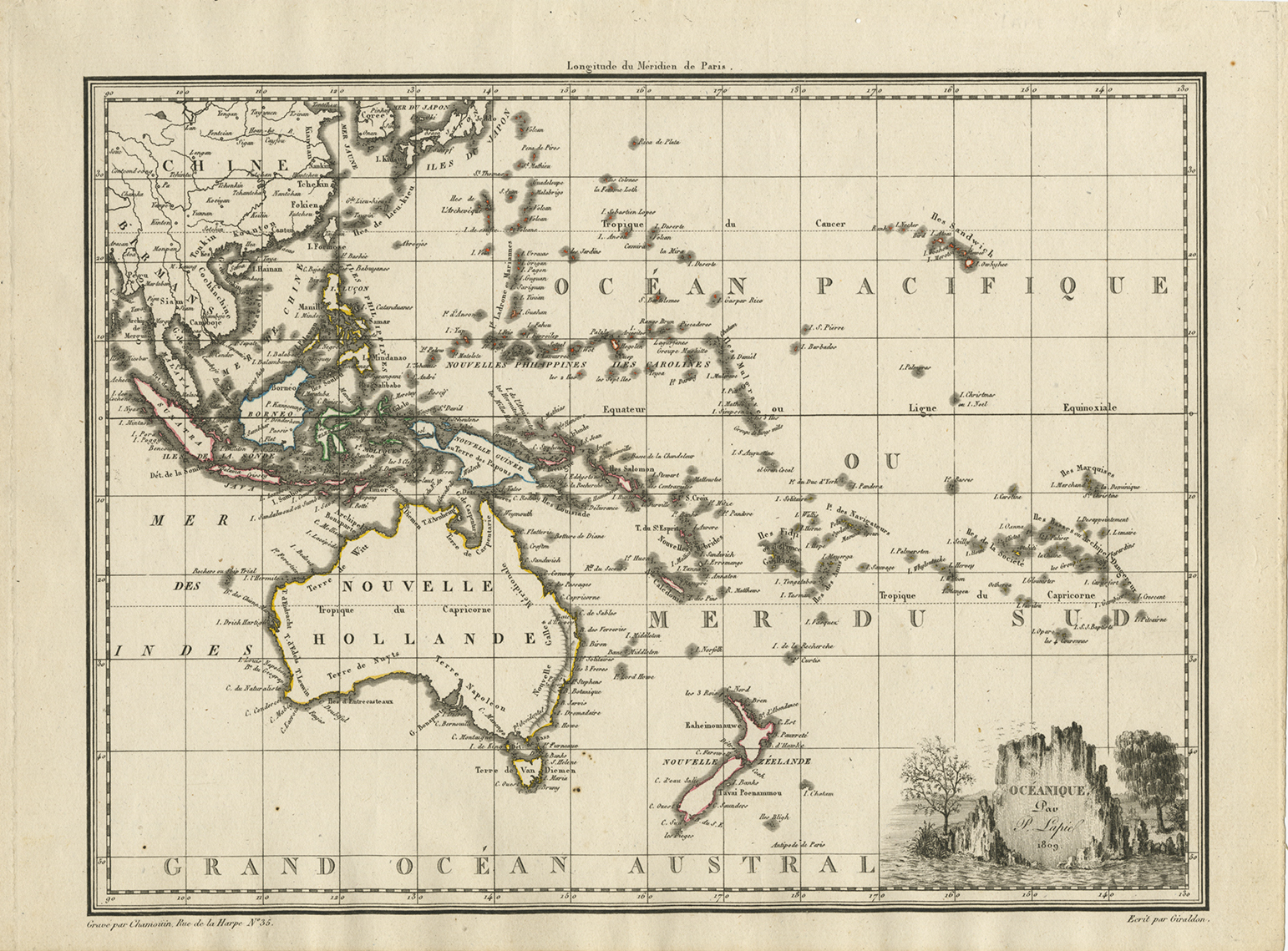
Antique map Australasia titled ‘Oceanique Australasian ~ 1809’.
French Australasian map, titled ‘Oceanique’ and including ‘Nouvelle Hollande’, using the Fench names given by the Boudain expedition, eg. ‘Terre de Napoleon’, before the revision from Matthew Flinders prior exploration of the same coast. By Pierre Lapie, dated 1809
Lapie’s map features an attractive vignette based on illustrations by Lesueur. Charles Lesueur was the young artist on Baudin’s voyage, famous for his fine illustrations of Australian animals.
Pierre Lapie was the first geographer to the King of France and Chief of the Topographic section of the War Office.
Artist: P. Lapie
Year: 1809
Medium: Copperplate engraving
Verso: Blank
Color: Modern outline.
Measurements: 290 x 221 mm.
Purchase Code:Â Â M2400
5.950.000 IDR
355,00 Euro
410,00 USD
Related Products
Motacilla, Flava – Sepp & Nozeman (1789)
Description: Antique print titled 'Motacilla, Flava'. This print depicts the Western yellow wagtail with nest and eggs (Dutch: gele kwikstaart). The western yellow wagtail (Motacilla flava) is a small passerine in the wagtail family Motacillidae, which also includes the pipits and longclaws. This species breeds in much of temperate Europe and Asia. It is resident in the milder parts of its range, such as western Europe, but northern and eastern populations migrate to Africa and south Asia.
This print originates from 'Nederlandsche Vogelen; volgens hunne huisdouding, aert, en eigenschappen beschreeven', Amsterdam, 1770-1829 by C. Nozeman, M. Houttuyn and J.C. Sepp. This is the most important and first study in the Netherlands of ornithology at that time. The birds are depicted as they are in life, said to be depicted close to life sized and in their environment.
Original text page included.
Artists and engravers:Â This monumental work is associated with Christiaan Andreas Sepp, Jan Christiaan Sepp, Jan Sepp, Cornelis Nozeman, Martinus Houttuyn and Coenraad Jacob Temminck.
- Date: 1789
- Overall size: 37 x 53 cm.
- Image size: 27.8 x 41.6 cm.
- Condition: Very good. General age-related toning. Please study image carefully.
Antique Map of the Moluccas by Porcacchi, ‘circa 1620’
Antique Print of Animals from Southeast Asia (c.1860)
Description: Antique print titled 'Süd-Asiatische Thiere'. Engraving of various animals of Southeast Asia including the tailor bird, cockatoo, a goose, hornbill, bird of paradise, a bengal tiger and a leopard species. Source unknown, to be determined.Â
Artists and Engravers: Anonymous.
- Date: c.1860
- Overall size: 19 x 25 cm.
- Image size: 18 x 23 cm.
- Condition: Good, general age-related toning. Some wear and soiling, blank verso. Please study image carefully.
De Werelt Caart – Danckerts (c.1720)
Description: Antique world map titled 'De Werelt Caart'. Double hemisphere world map showing Australia as Niew Hollandt and according to the discoveries made by Abel Tasman on his two voyages in 1642-44. California as an island and the north west coast of America is named Terra Esonis. In Asia, Korea is a elongated peninsula. The two main hemispheres are surrounded by six smaller spherical sections, two covering the polar surfaces of the earth, two showing astronomical measurements relative to the earth, one featuring a geocentric view of the solar system and the other representing the Sun and its relationship with both the Earth and the Moon showing how eclipses are produced. Originates from a Dutch bible.Â
Artists and Engravers:Â Made by or after C. Danckerts.Â
- Date: c.1720
- Overall size: 54.5 x 41 cm.
- Image size: 51.5 x 36.5 cm.
- Condition: Very good, original/contemporary hand coloring. Dutch text on verso, please study image carefully.