Antique Map Java by Van Linschoten (1598)
Product Information
Description
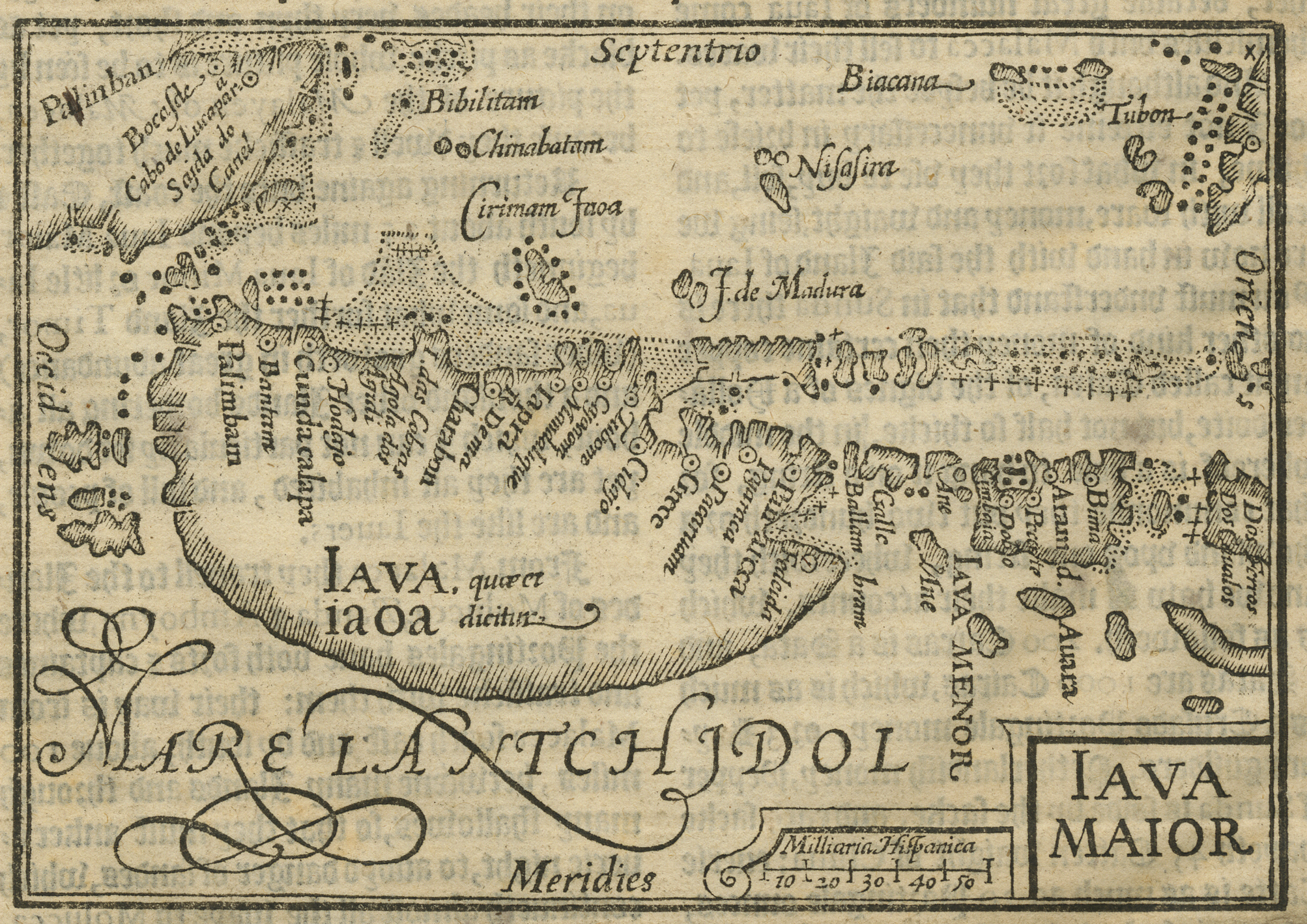
Antique Map Java by Van Linschoten titled ‘Iava Maior’ (Java Major).
A rare and interesting woodblock map on page with text, from ‘Iohn Huighen van Linschoten his discours of Voyages into ye Easte & West Indies’. The map is based on late 16th century Portuguese charts, and published in the first English edition of van Linschoten’s ‘Itinerario.
Van Linschoten was a Dutchman who had spent a lengthy period in Portuguese service in Goa. In gathering and publishing higherto unknown information and maps relating to the Spice Islands, he enabled the Dutch and English to challenge the Portuguese monopoly in the East Indies. The placenames on the maps in van Linschoten’s work are in Portuguese, and the last section is a brief history of Portugal, suggesting the possiblity that van Linschoten had perhaps obtained a manuscript copy of the Portuguese geographer Barros’ fabled, incomplete and unpublished work, ‘Treatise on Geography’.
Year: 1598 ( London )
Condition: Good – English text on verso.
Measures: Map: 126 x 87 mm / Page: 185 x 284 mm.
Purchase Code: M2509
9.300.000 IDR
540,00 Euro
625,00 USD
Related Products
Antique Map of Asia Minor by Lapie (1842)
Description: Antique map titled 'Carte de l'Asie Mineure Ancienne (..)'. Map of Asia Minor, also called Anatolia or Turkish Anadolu. This map originates from 'Atlas universel de géographie ancienne et moderne (..)' by Pierre M. Lapie and Alexandre E. Lapie.
Artists and Engravers: Pierre M. Lapie was a French cartographer and engraver. He was the father of cartographer Alexandre Emile Lapie.
- Date: 1842
- Overall size: 68 x 50.5 cm.
- Image size: 54.5 x 40 cm.
- Condition: Very good, general age-related toning. Original folding line, blank verso. Please study image carefully.
Antique Map South-East Asia by Hondius (1636)
Antique Map of the Asian Continent by Danckerts (1780) – SOLD
Antique Map of Asia by Elwe (1792) – SOLD
Antique Map of the East Indies by Blaeu (c.1640)
Description: Antique map titled 'India quae Orientalis dicitur et Insulae Adiacentes'. Beautiful map of Southeast Asia, extending from India to Tibet to Japan to New Guinea. It was the first popular map to depict part of Australia. Includes a dedicational cartouche to Laurens Real.
Artists and Engravers: Willem Janszoon Blaeu (1571-1638) was a prominent Dutch geographer and publisher. Born the son of a herring merchant, Blaeu chose not fish but mathematics and astronomy for his focus. He studied with the famous Danish astronomer Tycho Brahe, with whom he honed his instrument and globe making skills. Blaeu set up shop in Amsterdam, where he sold instruments and globes, published maps, and edited the works of intellectuals like Descartes and Hugo Grotius. In 1635, he released his atlas, Theatrum Orbis Terrarum, sive, Atlas novus. Willem died in 1638. He had two sons, Cornelis (1610-1648) and Joan (1596-1673). Joan trained as a lawyer, but joined his father’s business rather than practice. After his father’s death, the brothers took over their father’s shop and Joan took on his work as hydrographer to the Dutch East India Company. Later in life, Joan would modify and greatly expand his father’s Atlas novus, eventually releasing his masterpiece, the Atlas maior, between 1662 and 1672.
- Date: c.1640
- Overall size: 60 x 49.5 cm.
- Image size: 50.5 x 41 cm.
- Condition: Good, general age-related toning. Repair on folding line and repaired tear near Borneo. Few stains, mainly in margins. Dutch text on verso, please study image carefully.