Antique Map of part of the East Indies by Dornseiffen (1902)
Product Information
Product code: BGJC-011€125,00
Description
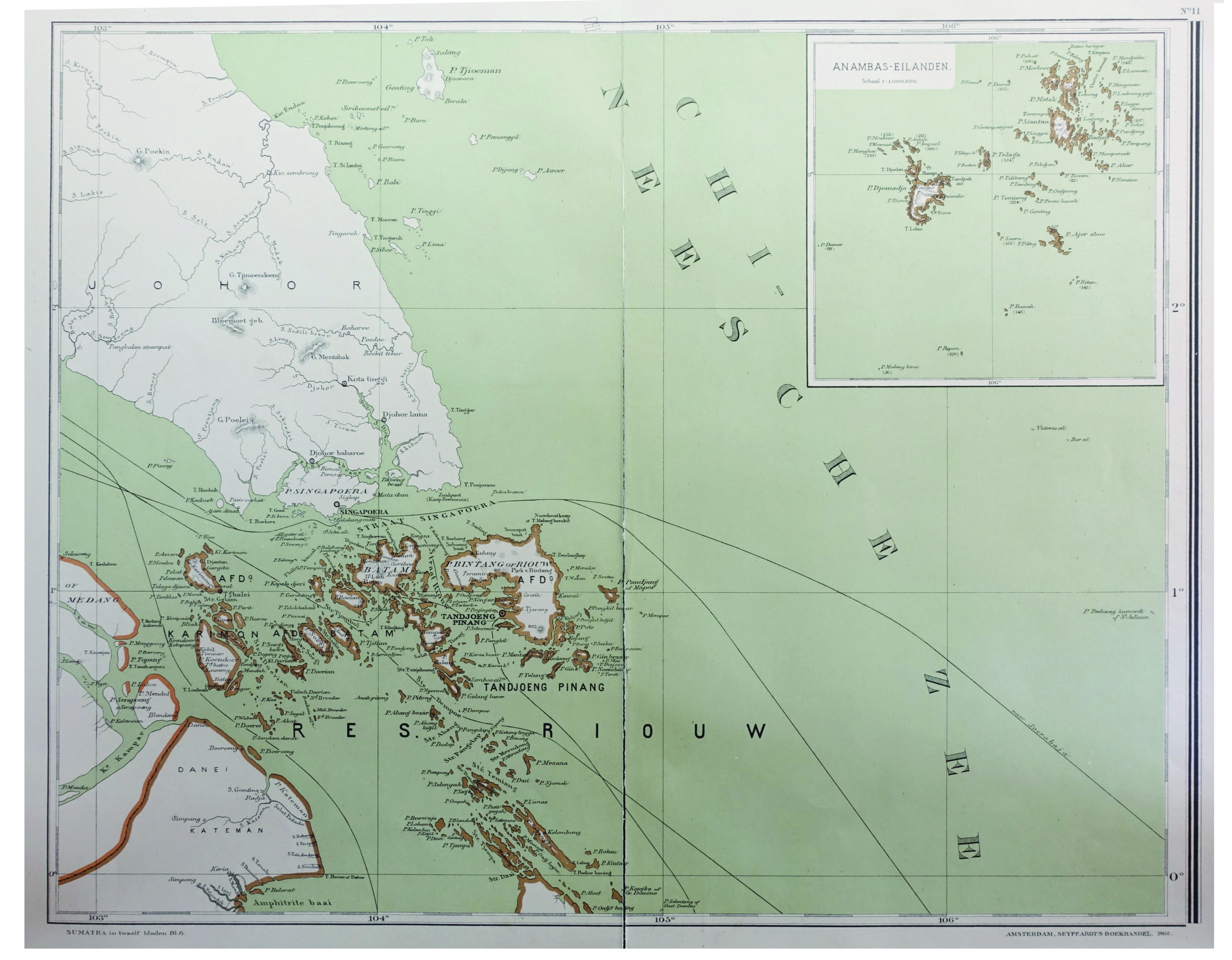
Untitled map of part of the East Indies. This map is sheet 6 of the Sumatra maps. It depicts the Riau islands and includes an inset map of the Anambas Islands, Indonesia. Anambas Islands Regency (Indonesian: Kabupaten Kepulauan Anambas) is a small archipelago of Indonesia, located 150 nautical miles northeast of Batam Island in the North Natuna Sea between the Malaysianmainland to the west and the island of Borneo to the east. Geographically part of the Tudjuh Archipelago, it is administratively a regency within the Riau Islands Province. This map originates from ‘Atlas van Nederlandsch Oost- en West-Indie’, by Dr I. Dornseiffen, published by Seyffardt’s Boekhandel, Amsterdam.
Condition: Very good, please study image carefully.
Size: 52 x 40 cm.
1.850.000,00 IDR
115,00 Euro
125,00 USD
Please do not hesitate to contact us if you would like to receive more information about this antique print.Â
Related Products
Antique Map of the Moluccas by Porcacchi, ‘circa 1620’
Antique Map of New Zealand by Blackie & Son (1883)
Antique Map of the East Indies by Blaeu (c.1640)
Description: Antique map titled 'India quae Orientalis dicitur et Insulae Adiacentes'. Beautiful map of Southeast Asia, extending from India to Tibet to Japan to New Guinea. It was the first popular map to depict part of Australia. Includes a dedicational cartouche to Laurens Real.
Artists and Engravers: Willem Janszoon Blaeu (1571-1638) was a prominent Dutch geographer and publisher. Born the son of a herring merchant, Blaeu chose not fish but mathematics and astronomy for his focus. He studied with the famous Danish astronomer Tycho Brahe, with whom he honed his instrument and globe making skills. Blaeu set up shop in Amsterdam, where he sold instruments and globes, published maps, and edited the works of intellectuals like Descartes and Hugo Grotius. In 1635, he released his atlas, Theatrum Orbis Terrarum, sive, Atlas novus. Willem died in 1638. He had two sons, Cornelis (1610-1648) and Joan (1596-1673). Joan trained as a lawyer, but joined his father’s business rather than practice. After his father’s death, the brothers took over their father’s shop and Joan took on his work as hydrographer to the Dutch East India Company. Later in life, Joan would modify and greatly expand his father’s Atlas novus, eventually releasing his masterpiece, the Atlas maior, between 1662 and 1672.
- Date: c.1640
- Overall size: 60 x 49.5 cm.
- Image size: 50.5 x 41 cm.
- Condition: Good, general age-related toning. Repair on folding line and repaired tear near Borneo. Few stains, mainly in margins. Dutch text on verso, please study image carefully.
Antique Map of the Asian Continent by Danckerts (1780) – SOLD
Antique Print of Chinese Punishment of the Rack by Allom (1859)
Description: Antique print titled 'Chinese Punishment of the Rack'. Print of Chinese punishment of the rack. The rack is a torture device consisting of a rectangular, usually wooden frame. This print originates from 'The Chinese Empire: historical and descriptive. Illustrating the manners and customs of the Chinese,in a series of steel engravings, from original sketches' by T. Allom
Artists and Engravers: Thomas Allom (1804–1872) was an English architect, artist, and illustrator, who published books on his travels from Europe to the Middle East and throughout Asia.
- Date: 1859
- Overall size: 27 x 19.5 cm.
- Image size: 23 x 16 cm.
- Condition: Good, general age-related toning. Minor wear, blank verso. Please study image carefully.