Antique Map of South-East Asia and the Philippines (1812)
Product Information
Description
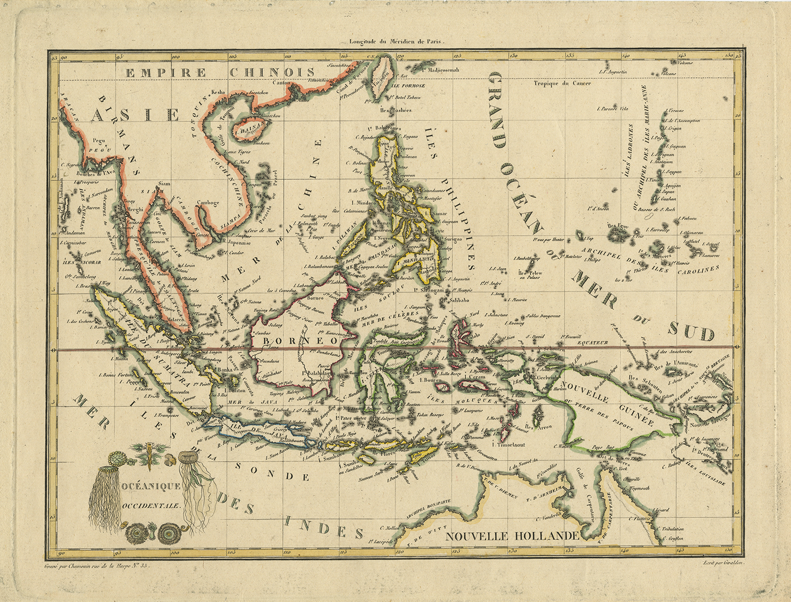
Antique Map of South-East Asia and the Philippines titled ‘Oceanique Occidentale’. Attractive map of the region bounded by Taiwan, Pegu and Northern Australia, centered on the Philippines and Borneo, by Malte Brun, published in 1812 in Paris. Malte Brun’s maps were very up to date and well researched, meaning that this map includes the most recent discoveries in the Pacific in the early 19th century.
Conrad Malte-Brun (12 August 1775 – 14 December 1826), born Malthe Conrad Bruun, and sometimes referred to simply as Malte-Brun, was a Dano-French geographer and journalist. His second son, Victor Adolphe Malte-Brun, was also a geographer.
Artist: C. Malte-Brun
Year: 1812
Dimensions 292 x 205 mm.
Condition Very good.
Coloring Outline coloring.
Technique Copperplate engraving.
Purchase Code: M2404
7.400.000 IDR
450,00 Euro
525,00 USD
Related Products
Antique World Map Twin Hemisphere by Visscher (c.1657)
Fringilla, Spinus – Sepp & Nozeman (1789)
Description: Antique print titled ‘Fringilla, Spinus'. This print depicts the Eurasian Siskin with nest and eggs (Dutch: Sijs). The Eurasian siskin (Spinus spinus) is a small passerine bird in the finch family Fringillidae. It is also called the European siskin, common siskin or just siskin. Other (archaic) names include black-headed goldfinch, barley bird and aberdevine.It is very common throughout Europe and Asia. It is found in forested areas, both coniferous and mixed woodland where it feeds on seeds of all kinds, especially of alder and conifers.
This print originates from 'Nederlandsche Vogelen; volgens hunne huisdouding, aert, en eigenschappen beschreeven', Amsterdam, 1770-1829 by C. Nozeman, M. Houttuyn and J.C. Sepp. This is the most important and first study in the Netherlands of ornithology at that time. The birds are depicted as they are in life, said to be depicted close to life sized and in their environment.
Original text page included.Â
Artists and engravers: This monumental work is associated with Christiaan Andreas Sepp, Jan Christiaan Sepp, Jan Sepp, Cornelis Nozeman, Martinus Houttuyn and Coenraad Jacob Temminck.
- Date: 1789
- Overall size: 37 x 53 cm.
- Image size: 27.5 x 41.3 cm.
- Condition: Very good. General age-related toning. Please study image carefully.
Antique Map of part of the East Indies by Dornseiffen (1902)
De Werelt Caart – Danckerts (c.1720)
Description: Antique world map titled 'De Werelt Caart'. Double hemisphere world map showing Australia as Niew Hollandt and according to the discoveries made by Abel Tasman on his two voyages in 1642-44. California as an island and the north west coast of America is named Terra Esonis. In Asia, Korea is a elongated peninsula. The two main hemispheres are surrounded by six smaller spherical sections, two covering the polar surfaces of the earth, two showing astronomical measurements relative to the earth, one featuring a geocentric view of the solar system and the other representing the Sun and its relationship with both the Earth and the Moon showing how eclipses are produced. Originates from a Dutch bible.Â
Artists and Engravers:Â Made by or after C. Danckerts.Â
- Date: c.1720
- Overall size: 54.5 x 41 cm.
- Image size: 51.5 x 36.5 cm.
- Condition: Very good, original/contemporary hand coloring. Dutch text on verso, please study image carefully.