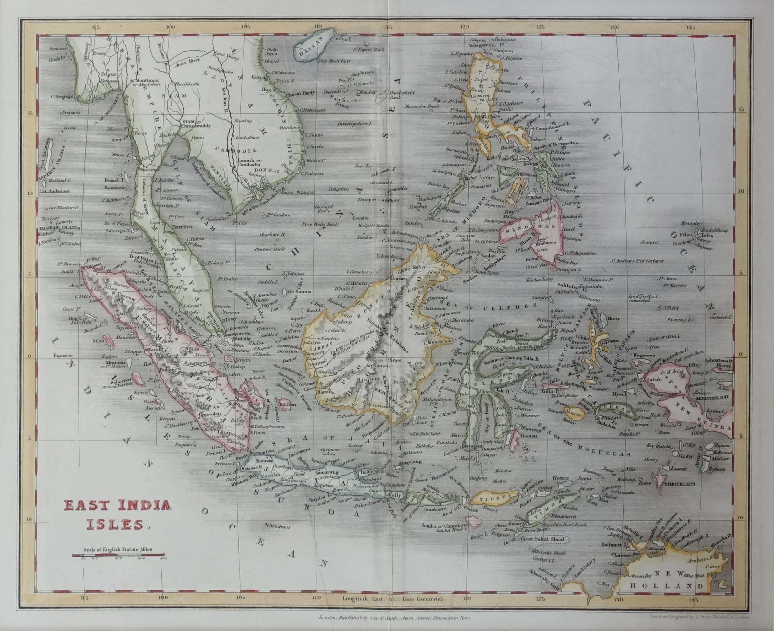
Antique Map of the East Indies by Higgins (1832)
Product Information
Product code: M0553€195,00
Description
Antique map of the East Indies titled ‘East India Isles’. Map of Southeast Asia, extending from Hainan in Southern China, east to Burma, south to Sumatra and Java and east to the Pelew Islandsd and Papua New Guinea. Also shows part of New Holland/Australia.
This map originates from ‘A General Descriptive Atlas Of The Earth, Containing Separate Maps Of The Various Countries And States, From Original Drawings. With A Short Account Of Each Country, Descriptive Of Its Geographical Features, Chief Towns And Cities, Population, And General Statistics’ published by W.S. Orr & Co.
Condition: Very good, please study image carefully.
Overall size:Â 40 x 35 cm (including passe-partout)
Image size:Â 28 x 23 cm.
2.800.000,00 IDR
175,00 Euro
195,00 USD
Please do not hesitate to contact us if you would like to receive more information about this antique print.Â
Related Products
Antique Map of the Moluccas by Porcacchi, ‘circa 1620’
Fringilla, Spinus – Sepp & Nozeman (1789)
Description: Antique print titled ‘Fringilla, Spinus'. This print depicts the Eurasian Siskin with nest and eggs (Dutch: Sijs). The Eurasian siskin (Spinus spinus) is a small passerine bird in the finch family Fringillidae. It is also called the European siskin, common siskin or just siskin. Other (archaic) names include black-headed goldfinch, barley bird and aberdevine.It is very common throughout Europe and Asia. It is found in forested areas, both coniferous and mixed woodland where it feeds on seeds of all kinds, especially of alder and conifers.
This print originates from 'Nederlandsche Vogelen; volgens hunne huisdouding, aert, en eigenschappen beschreeven', Amsterdam, 1770-1829 by C. Nozeman, M. Houttuyn and J.C. Sepp. This is the most important and first study in the Netherlands of ornithology at that time. The birds are depicted as they are in life, said to be depicted close to life sized and in their environment.
Original text page included.Â
Artists and engravers: This monumental work is associated with Christiaan Andreas Sepp, Jan Christiaan Sepp, Jan Sepp, Cornelis Nozeman, Martinus Houttuyn and Coenraad Jacob Temminck.
- Date: 1789
- Overall size: 37 x 53 cm.
- Image size: 27.5 x 41.3 cm.
- Condition: Very good. General age-related toning. Please study image carefully.
Antique Print of Chinese Punishment of the Rack by Allom (1859)
Description: Antique print titled 'Chinese Punishment of the Rack'. Print of Chinese punishment of the rack. The rack is a torture device consisting of a rectangular, usually wooden frame. This print originates from 'The Chinese Empire: historical and descriptive. Illustrating the manners and customs of the Chinese,in a series of steel engravings, from original sketches' by T. Allom
Artists and Engravers: Thomas Allom (1804–1872) was an English architect, artist, and illustrator, who published books on his travels from Europe to the Middle East and throughout Asia.
- Date: 1859
- Overall size: 27 x 19.5 cm.
- Image size: 23 x 16 cm.
- Condition: Good, general age-related toning. Minor wear, blank verso. Please study image carefully.
Asien gegen ende des 18th Jahrhunderts – Spruner (1855)
Description: Antique map Asia titled ‘Asien gegen ende des 18th Jahrhunderts. Die Briten in Indien; das Reich der Mandschu‘. This fascinating hand colored map depicts Asia at the end of the 18th century. The British had established themselves in India and the Chinese Empire was under Manchu control. Also depicts Southeast Asia in good detail with early versions of Vietnam (Anam & Tonkin), Cambodia (Kambodscha) and Thailand.
Artists and Engravers: Karl Spruner von Merz (15 November 1803 – 24 August 1892), or Karl von Spruner as he preferred to be known, was a German cartographer and scholar. He is best known for his historical atlases. The first of these was his Historischer Atlas von Bayern (historical atlas of Bavaria), published in 1838. His greatest work was his Historisch-Geographischer Hand-Atlas, whose first edition appeared in parts from 1848 to 1853.
- Date: 1853
- PartNumber: 232
- Storage Location: (BG) B3-20
Antique Map of Australia, the East Indies and Africa by J.J. Gebauer (c.1760)
Antique Map of the East Indies by Blaeu (c.1640)
Description: Antique map titled 'India quae Orientalis dicitur et Insulae Adiacentes'. Beautiful map of Southeast Asia, extending from India to Tibet to Japan to New Guinea. It was the first popular map to depict part of Australia. Includes a dedicational cartouche to Laurens Real.
Artists and Engravers: Willem Janszoon Blaeu (1571-1638) was a prominent Dutch geographer and publisher. Born the son of a herring merchant, Blaeu chose not fish but mathematics and astronomy for his focus. He studied with the famous Danish astronomer Tycho Brahe, with whom he honed his instrument and globe making skills. Blaeu set up shop in Amsterdam, where he sold instruments and globes, published maps, and edited the works of intellectuals like Descartes and Hugo Grotius. In 1635, he released his atlas, Theatrum Orbis Terrarum, sive, Atlas novus. Willem died in 1638. He had two sons, Cornelis (1610-1648) and Joan (1596-1673). Joan trained as a lawyer, but joined his father’s business rather than practice. After his father’s death, the brothers took over their father’s shop and Joan took on his work as hydrographer to the Dutch East India Company. Later in life, Joan would modify and greatly expand his father’s Atlas novus, eventually releasing his masterpiece, the Atlas maior, between 1662 and 1672.
- Date: c.1640
- Overall size: 60 x 49.5 cm.
- Image size: 50.5 x 41 cm.
- Condition: Good, general age-related toning. Repair on folding line and repaired tear near Borneo. Few stains, mainly in margins. Dutch text on verso, please study image carefully.