[vc_row][vc_column][vc_column_text]
Batavia Collection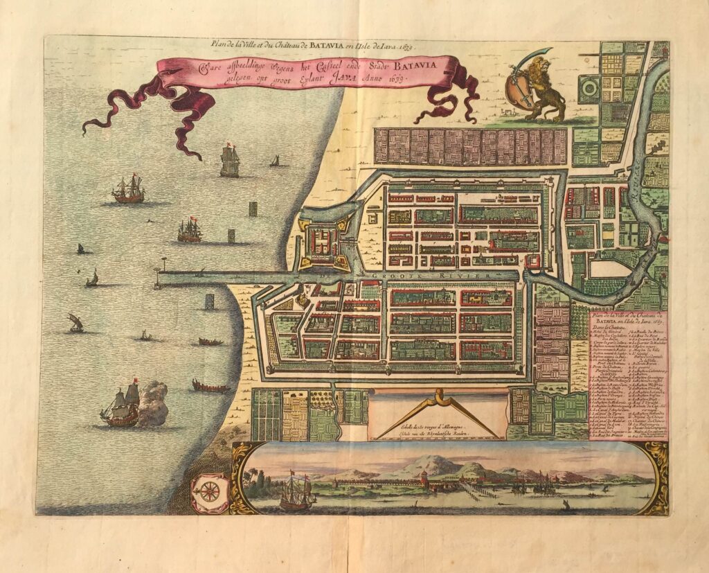
From Wikipedia
Batavia, also called Batauia in the city’s Malay vernacular, was the capital of the Dutch East Indies. The area corresponds to present-day Jakarta, Indonesia. Batavia can refer to the city proper or its suburbs and hinterland, the Ommelanden, which included the much-larger area of the Residency of Batavia in the present-day Indonesian provinces of Jakarta, Banten and West Java.
The founding of Batavia by the Dutch in 1619, on the site of the ruins of Jayakarta, led to the establishment of a Dutch colony; Batavia became the center of the Dutch East India Company’s trading network in Asia. Monopolies on local produce were augmented by non-indigenous cash crops. To safeguard their commercial interests, the company and the colonial administration absorbed surrounding territory.
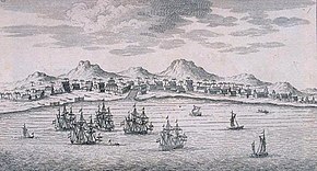
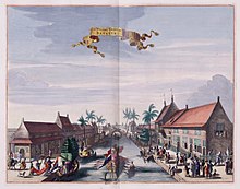
Batavia is on the north coast of Java, in a sheltered bay, on a land of marshland and hills crisscrossed with canals. The city had two centers: Oud Batavia (the oldest part of the city) and the relatively-newer city, on higher ground to the south.
It was a colonial city for about 320 years until 1942, when the Dutch East Indies was occupied by Japan during World War II. During the Japanese occupation and after Indonesian nationalists declared independence on 17 August 1945, the city was known as Jakarta. It was internationally known by its Dutch name until Indonesia achieved full independence in 1949, when the city was renamed Jakarta.
Arrival
Amsterdam merchants embarked on an expedition to the East Indies archipelago in 1595 under the command of Cornelis de Houtman. The English East India Company’s first voyage in 1602, commanded by James Lancaster, arrived in Aceh and sailed on to Bantam. There, Lancaster was allowed to build a trading post which was the center of English trade in Indonesia until 1682.
The Dutch government granted the Dutch East India Company a monopoly on Asian trade in 1602. A year later, the first permanent Dutch trading post in Indonesia was established in Bantam, West Java. Prince Jayawikarta gave Dutch merchants permission to build a wooden warehouse and houses on the east bank of the Ciliwung River opposite Jayakarta in 1610, and the outpost was established the following year. As Dutch power increased, Jayawikarta allowed the English to build houses on the west bank of the Ciliwung and a fort near his customs office to maintain a balance of power.
Tensions between Prince Jayawikarta and the Dutch escalated until 1618, when Jayawikarta’s soldiers besieged the Dutch fortress containing the Nassau and Mauritius warehouse. An English fleet of 15 ships arrived under Thomas Dale, former governor of the colony of Virginia. After a sea battle, newly-appointed Dutch governor Jan Pieterszoon Coen escaped to the Moluccas to seek support; the Dutch had taken over the first of the Portuguese forts there in 1605. Dutch garrison commander Pieter van den Broecke and five other men were arrested during negotiations, since Jayawikarta believed that he had been deceived by the Dutch. Jayawikarta and the English then forged an alliance.
The Dutch army was on the verge of surrendering to the English when, in 1619, the Sultanate of Banten sent a group of soldiers to summon Jayawikarta. Jayawikarta’s agreement with the English had not been approved by the Bantenese authorities. The conflict between Banten and Jayawikarta and the tense relationship between Banten and the English provided a new opportunity for the Dutch. Coen returned from the Moluccas with reinforcements on 28 May 1619, razing Jayakarta to the ground two days later and expelling its population. Only the Luso-Sundanese padrão remained.
Jayawikarta retreated to Tanara, in the interior of Banten, where he later died. The Dutch established a closer relationship with Banten and assumed control of the port, which became the regional Dutch center of power.
Founding
The region which became Batavia came under Dutch control in 1619, initially as an expansion of the original Dutch fort and a new building on the ruins of the former Jayakarta. Coen decided to expand the original fort into a larger fortress on 2 July 1619, and sent plans for Batavia Castle to the on 7 October of that year. The castle was larger than the previous one, with two northern bastions protecting it from a maritime attack. The Nassau and Mauritius warehouses were expanded with the erection of an eastern fort extension, overseen by Commander Van Raay, on 12 March 1619.
Although Coen wanted to name the new settlement Nieuw-Hoorn after Hoorn (his birthplace), he was prevented from doing so by the board of the East India Company. Batavia was chosen as the new name of the fort and settlement, and a naming ceremony was held on 18 January 1621.It was named after the Germanic tribe, which inhabited the Batavian region during the Roman Empire; at the time, it was believed that the tribe was the ancestors of the Dutch people. Jayakarta was called Batavia for over 300 years.
There were three governmental administrations in the Batavia region. Initial authority was established in 1609 and became the colonial High Government, consisting of the Governor-General and the Council of the Indies. The urban (or civil) administration of the city of Batavia was established in 1620. On 24 June 1620, two company officials and three free citizens (or burghers) were appointed to the first College of Aldermen. The local rural administration, formed in 1664, became fully functional in 1682. The Javanese people were prohibited from settling in Batavia from the time of its founding in 1619.
Expansion

From its founding, Batavia was planned in a well-defined layout. Three trenches were dug east of the Ciliwung River in 1619, its first Dutch-made canals. The canals were named (from south to north) Leeuwengracht, Groenegracht, and Steenhouwersgracht.The Castle area begins in a former field north of Steenhouwersgracht, in which a town market was established. The first church and town hall were built c. 1622 on the east bank of the river; Batavia’s first combined church and town hall (replaced during the 1630s) was at 6°07′56″S 106°48′42″E.
Eastern Batavia was protected by a long canal which linked the castle moat and the Ciliwung riverbend, and ran at a slight angle to Tijgersgracht. The canal cost over 160,000 real, which was paid mostly by the Chinese and other Europeans instead of the company (who had strengthened the Castle with slave and prison labor. The short-lived outer canal was redesigned several years after the 1628–29 Siege of Batavia.

East of Batavia, Sultan Agung (king of the Mataram Sultanate) gained control of most of Java by defeating Surabaya in 1625.On 27 August 1628, Agung began the Siege of Batavia. After heavy losses in his first attempt, he retreated and launched a second offensive the following year. This also failed; the Dutch fleet destroyed his supplies and ships in the harbors of Cirebon and Tegal. Mataram troops, starving and decimated by illness, retreated again. Agung then moved east, attacking Blitar, Panarukan and the Blambangan Kingdom in eastern Java (a vassal state of the Balinese kingdom of Gelgel).
After the siege, it was decided that Batavia needed a stronger defense system. Based on the work of Flemish mathematician and military engineer Simon Stevin, Governor-General Jacques Specx designed a moat and city wall; extensions of the wall were built west of Batavia, and the city was completely enclosed.
In 1656, due to a conflict with Banten, the Javanese were not allowed to live within the city walls and settled outside Batavia. The Chinese and the Mardijkers were the only non-Dutch settlers within the walled city. In 1659, A 1659 truce with Banten enabled the city to grow, and more bamboo houses were built. Bamboo houses and livestock were banned in 1667, and the wealthy Dutch built tall houses and canals.
We have 100’s of Batavia Maps and Prints available in our collection online, in our Gallery and our global website Maps & Prints[/vc_column_text][vc_separator border_width=”3″][/vc_column][/vc_row][vc_row][vc_column][vc_column_text]
The Batavia Collection
[/vc_column_text]
[/vc_column][/vc_row][vc_row][vc_column][vc_separator border_width=”3″][vc_column_text]Batavia Collection – Maps and Prints
(Please also visit www.eastindies.art – East Indies Art has a creatively diverse collection of reproduced antique maps, prints, vintage posters and photographs, here you will find a breadth of artwork to turn any interior into an artful sanctuary. And for 1000’s more global maps and print products visit www.maps-prints.com)
[/vc_column_text][/vc_column][/vc_row][vc_row][vc_column][vc_separator border_width=”3″][/vc_column][/vc_row]