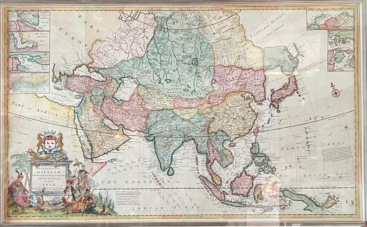
Map of Asia – Herman Moll (c.1710)
A highly detailed map of ASIA, by a respected English cartographer in the early 18th century, Herman Moll (1654-1732)
A highly detailed map of ASIA, titled ‘To the Right Honorable William Lord Cowper, Lord High Chancellor of Great Britain, This Map of Asia according to ye Newest & Most Accurate Observations’ by a respected English cartographer in the early 18th century, Herman Moll (1654-1732), with original hand-colour outline. The dedication within an elaborate historiated cartouche surmounted by the arms of the dedicatee, William, the first Earl Cowper, showing the wealth of Asia.
Artist and cartographer : Herman Moll (1654-1732) was the most important cartographer working in London during his era, a career that spanned over fifty years. His origins have been a source of great scholarly debate; however, the prevailing opinion suggests that he hailed from the Hanseatic port city of Bremen, Germany. Joining a number of his countrymen, he fled the turmoil of the Scanian Wars for London, and in 1678 is first recorded as working there as an engraver for Moses Pitt on the production of the English Atlas .
It was not long before Moll found himself as a charter member of London’s most interesting social circle, which congregated at Jonathan’s Coffee House at Number 20 Exchange Alley, Cornhill. It was at this establishment that speculators met to trade equities (most notoriously South Sea Company shares). Moll’s coffeehouse circle included the scientist Robert Hooke, the archaeologist William Stuckley, the authors Jonathan Swift and Daniel Defoe, and the intellectually-gifted pirates William Dampier, Woodes Rogers and William Hacke.
From these friends, Moll gained a great deal of privileged information that was later conveyed in his cartographic works, some appearing in the works of these same figures. Moll was highly astute, both politically and commercially, and he was consistently able to craft maps and atlases that appealed to the particular fancy of wealthy individual patrons, as well as the popular trends of the day. In many cases, his works are amongst the very finest maps of their subjects ever created with toponymy in the English language. (Ref. Shirley, Maps in the Atlases of the British Library I, T.Moll-4b, 4; Cf. Reinhartz, The Cartographer and the Literati: Herman Moll and his Intellectual Circle.)
Measurements : 1.250 x 870 mm (incl.FRAME)
Conditions : Good, only a small tear at the side.
Purchase code : M0893