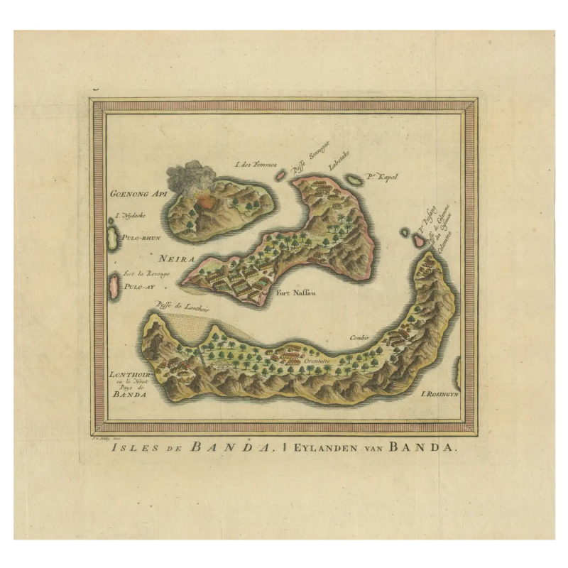
Map of the Banda Island – Van der Schley (c.1753) – SOLD
Isles de Banda / Eylanden van Banda
Map of the Banda islands. Isles de Banda / Eylanden van Banda by Jakob Van der Schley. He based this chart on one contained in ‘Het tvveede boeck, iournael oft dagh-register’ by Jacob Cornelisz van Neck,.
This original antique engraving provides a detailed map of the Banda Islands, a group of ten small volcanic islands in the Banda Sea, central to the historic spice trade. The map showcases the islands’ topography, with lush greenery and hilly terrain, hinting at the once-abundant presence of nutmeg and mace which were native to the islands.
Highlighted on the map is Fort Nassau, a significant Dutch fortress during the spice trade era, indicating its role in the defense and administration of the islands for controlling the valuable spice resources. The map’s legend, probably in French, points to various landmarks, including the names of individual islands like Neira, and possibly mentions other smaller forts or points of interest.
The engraving’s coloration is muted, with earthy tones for the land and a soft green for vegetation, suggesting the map’s age and artistic style. The sea surrounding the islands is left mostly uncoloured, drawing attention to the detailed coastline and the strategic positioning of the fortifications. This map is not just a geographic depiction but also a historical document, revealing the extent of European colonization and its impact on the region. It would have been used for navigation and to assert territorial claims during a time when maps were as much political tools as they were aids to navigation.
This map is not just a geographic depiction but also a historical document, revealing the extent of European colonization and its impact on the region. It would have been used for navigation and to assert territorial claims during a time when maps were as much political tools as they were aids to navigation.
The Banda Islands, historically known as the original and sole location for the production of nutmeg and mace, have a rich and tumultuous history marked by colonial ambitions and trade. The earliest European contact was made by the Portuguese in 1511, shortly after conquering Malacca, a major Asian trade hub. The Portuguese expedition, led by António de Abreu, used Malay pilots to navigate to Banda and established the first European contact with the islands in early 1512. The Bandanese were initially resistant to Portuguese attempts to control the trade and did not allow them to build a permanent fort or outpost on the islands.
The Dutch followed, with the Dutch East India Company (VOC) arriving in 1599, aiming to establish a monopoly over the lucrative spice trade. Dutch-Bandanese relations were fraught with tension and conflict. The Bandanese resisted Dutch control, leading to the Dutch conquest of the Banda Islands between 1609 and 1621, during which the Dutch used force and violence to subdue the local population. This resulted in the infamous Banda massacre, where thousands of Bandanese were killed or enslaved, and the remaining population was expelled. The VOC then established a plantation system on the islands, bringing in labor from other parts of Indonesia and beyond to work the nutmeg plantations, thus securing a Dutch monopoly on nutmeg production.
Today, the Banda Islands are recognized for their rich biodiversity, both on land and in the surrounding Coral Triangle, which is renowned for its coral reefs and marine life diversity. The islands are also culturally significant, with traditions such as the Cakalele dance and the Kora-Kora boat races reflecting the islands’ history and heritage. The Banda Islands’ colonial buildings, forts, and remnants of the plantation system are a testament to their historical importance as a center of spice trade and colonial exploitation.
Condition :Very good .A few flattened folding lines. Later Hand-Coloring.
Measures : 280 mm x 300 mm
Purchase code : BG-13268-3