Subtotal: $100,00
- Selection Required: Select product options above before making new offer.
- Error: There was an error sending your offer, please try again. If this problem persists, please contact us.
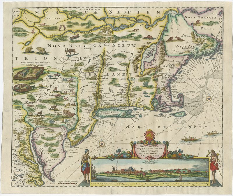
Map of New York (New Amsterdam) – Danckerts (1653-1655)
$9.500,00
Description
Original titled ; Novi Belgii Novaeque Angliae Nec Non Pennsylvaniae et Partis Virginiae Tabula multis in locis emendata . . .
A very attractive example from this famous and much sought after map, with an inset view of the Dutch colony on Manhattan Island, the second published view of New York, after Hartgers view of 1651. The cartographic information is based upon Jansson’s map of 1650. In 1655, Danckerts copied Nicholas Visscher, who in turn utilized Jansson’s map, with its vignettes of animals and Indian life, and added this now famous view of New Amsterdam, showing the Battery and Dutch buildings on the waterfront.
An extensive study of the map by Stokes suggests that the view was drawn sometime between 1653 and 1655, prior to the construction of New York’s wall. The first state of the map, copied from Visscher’s map, also omits Philadelphia. This second state was issued in about 1684 and shows Philadelphia for the first time, as well as adding farm animals.
The addition of domesticated farm animals in the New Netherlands colony is of historical note. The Dutch colonists were, by the 1680s, increasingly disillusioned with the support they were receiving from Holland. A delegation was sent to Den Haag to appeal for more support, money, settlers, etc. One of the by-products of the colonist’s meeting/plea was the revision of this map as a propaganda tool, displaying farm animals in New England in order to entice prospective new colonists to emigrate, on the theory that life in the New World was similar to life in Holland.
Artists and Engravers: Made by Justus Danckerts (1635-1701) , after original engraving from Nicolas Visscher (1618-1709). Published in Amsterdam, 1655.
- Date: 1653-1655
- Technic: Engraving / etching on hand laid paper.
- Overall size: 20 x 23 inch
- Condition: A small spots on the back and a small tear at the bottom. Not affecting the image.
- Purchase code : PB001
Related products
-
 $145,00
 -
$55,00
-
$2.388,00
-
$200,00