Subtotal: $105,00
- Selection Required: Select product options above before making new offer.
- Error: There was an error sending your offer, please try again. If this problem persists, please contact us.
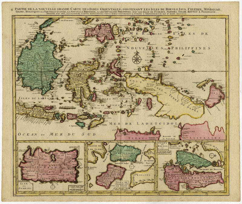
Partie de la Nouvelle Grande Carte des Indes Orientales (..) – Elwe (1792)
$875,00
Detailed map of the Indonesian islands Borneo, Celebes, and New Britain, as well as part of Java. Some of the smaller islands include Bali, Lombok, Timor and Madura
Description
Description: Antique map, titled: ‘Partie de la Nouvelle Grande Carte des Indes Orientales, contenant les Isles de Borneo, Iava, Celebes, Mindanao […]’
Detailed map of the Indonesian islands Borneo, Celebes, and New Britain, as well as part of Java. Some of the smaller islands include Bali, Lombok, Timor and Madura. Three inset maps in the lower edge depict Pulau Sumbawa, the Solor Islands Adonara (here Serbira) and Solor, and Pulau Muna (here Pangesane) and Bouton. One of the four sheets of Elwe’s map of South East Asia, based on Jaillot’s work, ca. 100 years ealier. Published in Amsterdam.
Artists and Engravers: Cartographer: Jan Barend Elwe. Jan Barend Elwe (1774-1815), an Amsterdam bookseller.
- Date: 1792
- Technic: Etching/engraving, contemporary hand colouring on hand laid paper. Watermark
- Overall size: 26 x 21,8 inch
- Image size: 23,5 x 20,5 inch
- Condition: Very good, given age. Original middle fold, as issued. A fine copy, with only some slight age-related browning and a few small stains. General age-related toning and/or occasional minor defects from handling. Please study scan carefully.
- PartNumber: 56912
- Storage Location: BG-B3-15
Related products
-
 $830,00
 -
$0,00
-
$3.600,00
-