
Description
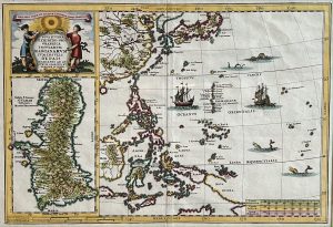
Antique map of the Mariana Islands titled ‘Nova Et Vera Exhibito Geographica Insularum Marianarum Cum Insulis De Pais Marianis ad Austrum Obiectic Nuperrime Inventis’. Fascinating map of the the Philippines, China, Japan and Korea, with a large inset of Guam. This map orginates from Scherer’s ‘Atlas Novus’.
Heinrich Scherer (1628-1704) was a Professor of Hebrew, Mathematics and Ethics at the University of Dillingen until about 1680. Thereafter he obtained important positions as Official Tutor to the Royal Princes of Mantua and Bavaria. It was during his time in Munich as Tutor to the Princely house of Bavaria that his lifetime’s work as a cartographer received acclaim and recognition.
Condition: Very good, please study image carefully.
Overall size: 47 x 36 cm (including passe-partout)
Image size: 35 x 24 cm.
Purchase code : M0314
35.400.000,00 IDR incl.passepartout
2.200,00 Euro incl.passepartout
2.450,00 USD incl.passepartout
Please do not hesitate to contact us if you would like to receive more information about this antique print.